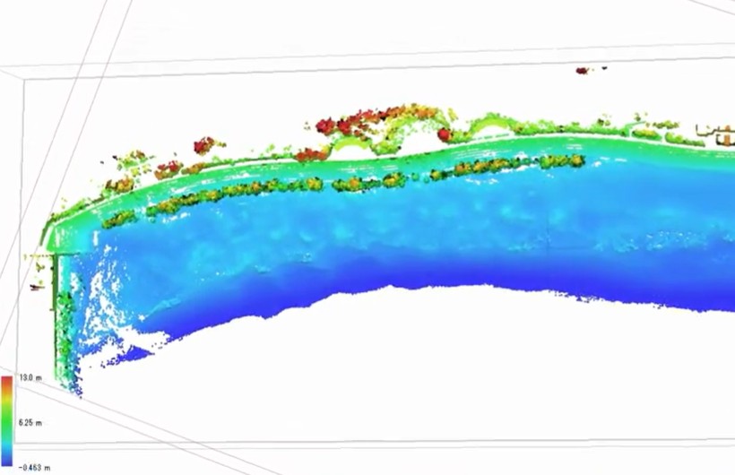
Skip to content
June 7, 2026
  • JPGU発表・六甲山地形のマイクロ浸食
  • 研究ニュース・博士課程の澤田さんがニュージランドの大学とオーストラリアの研究所で火山軽石の新研究結果
  • Huazhu Zheng successfully defended his PhD in Shanghai. Congratulation Doctor.
  • 新論文:The Afsarabad Landslide: Geomorphology, mineralogy and geotech published in Environ Earth Sci (IF:2.8)
地形・水文学・災害

地形・水文学・災害

Exploring Sediment Hazards, Disaster Risk, and Environmental Science

Platforms

QGIS - open source GIS desktop platform with numerous open-source plugins (International - Europe-centered development)

Cloud-Compare - Pointcloud Analysis Freeware (French System with several international plugins)

OpenFOAM within (or not) SALOME Platform (French Simulation system)

Dataset

OpenTopography LiDAR, SfM and other pointcloud sources (USA)

USGS Earth Explorer Remote Sensing Data for the whole planet (USA)

  • Education
    • Glossary of terms SABO・砂防 (和英)Jp-Eng
    • Laboratory and PhD Classes
    • Undegraduate Education
  • Photos
    • Asakura Field work with French and Tokyo U. Researchers
    • Photos Hodaka Research Station
    • Photos of Niigata’s coastal dune (2025)
  • PUBLICATIONS
  • Research Presentations
  • Research Projects
    • NOTO PENINSULA EARTHQUAKE PROJECT   能登半島地震災害と防災プロジェクト(土砂災害と水害)
    • Radar detection of in-flow driftwood and large wood
  • TOOLS & CODES
    • 1D Crank-Nicholson Implicit
    • Python Codes
  • The Team
Headlines
  • JPGU発表・六甲山地形のマイクロ浸食

    4 days ago
  • 研究ニュース・博士課程の澤田さんがニュージランドの大学とオーストラリアの研究所で火山軽石の新研究結果

    2 weeks ago2 weeks ago
  • Huazhu Zheng successfully defended his PhD in Shanghai. Congratulation Doctor.

    3 weeks ago3 weeks ago
  • 新論文:The Afsarabad Landslide: Geomorphology, mineralogy and geotech published in Environ Earth Sci (IF:2.8)

    3 weeks ago3 weeks ago
  • 新論文: 雲仙の溶岩ドーム移動Long-term deformation and surface change of the Heisei-Shinzan lava dome revealed by integrated monitoring

    4 weeks ago3 weeks ago
  • 新論文・New paper in Journal of Ecological Engineering on Microplastics in Merapi Volcano’s water springs

    4 weeks ago4 weeks ago
  • Home
  • SfM
  • 1944年、北海道沙流川の流域仮想現実
  • 3D
  • Hokkaido
  • Point Cloud
  • SfM

1944年、北海道沙流川の流域仮想現実

kaikikazanbear9 months ago01 mins

SfM-MVSの写真測量技術を利用して,過去の氾濫原地形を作成が出来る。20世紀の自然現象のシミュレションと土地被覆の研究にもつながる。

Post navigation

Previous: Teshima-san (4th year) and Sawada-san (D1) went to collect data in Hokkaido (Iburi and Usu Volcano) for their research
Next: 点群データで作戦された森林内の花崗岩ガリー

Related News

JPGU2026: Ground and Vegetation Extraction Algorithm for Steep Walls Gullies Recorded from mobile Laser Scanner

kaikikazanbear1 month ago1 month ago 0

Minatohama SLAM pointcloud みなとはまの点群データ(宮城県2026年)

kaikikazanbear3 months ago3 months ago 0

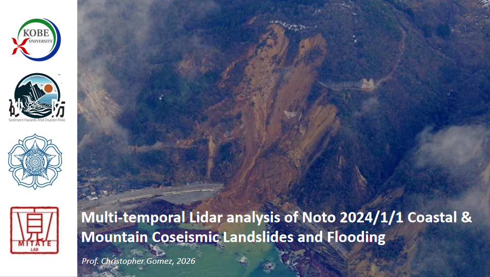
新英論文: C. Gomez. 2026. Airborne Lidar for Post-Disaster Recovery in Japan – Lessons from coseismic landslides and lifeline impacts in the aftermath of the January 1st 2024 Noto Peninsula Earthquake. British Geological Survey Geohorizons

kaikikazanbear4 months ago4 months ago 0

フランスのCNRSと福島の共同国際研究所MITATEにて、ゴメス教授が招待講演「能登半島地震の地滑りと水害災害」

kaikikazanbear4 months ago4 months ago 0

SABO is the science, engineering and art of sediment disaster risk reduction. It has no real equivalent in the Western part of the world, nor outside Asia. At the laboratory, and from this lense, we are finding solutions to natural hazards and disaster risk reduction, climate change and sustainability issues, concentrating on the island arcs of Japan and Indonesia mostly.

PI: Prof. Christopher Gomez

Come and work, learn, enjoy SABO, Geomorphology and climate change hazards and disaster risks with us. Let's work towards sustainable communities.

Publications

The summit of UnzenFugenDake